Oxholm’s West Indies maps and drawings: St. Thomas
One of the best collections of maps and drawings from the Danish West Indies was made by the officer Peter Lotharius Oxholm in the years 1778-1780. The collection contains 32 maps and drawings, including 11 maps from St. Thomas.
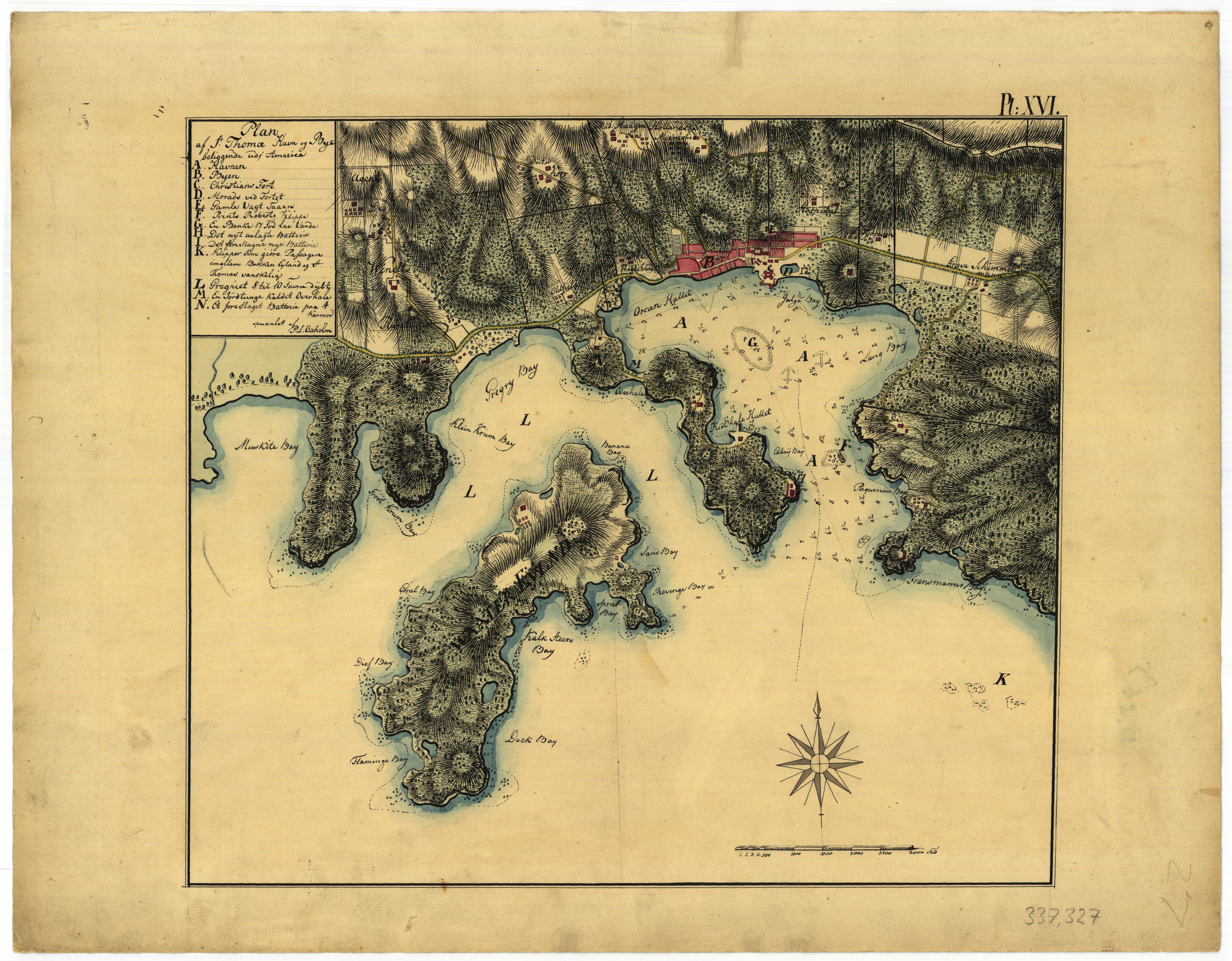
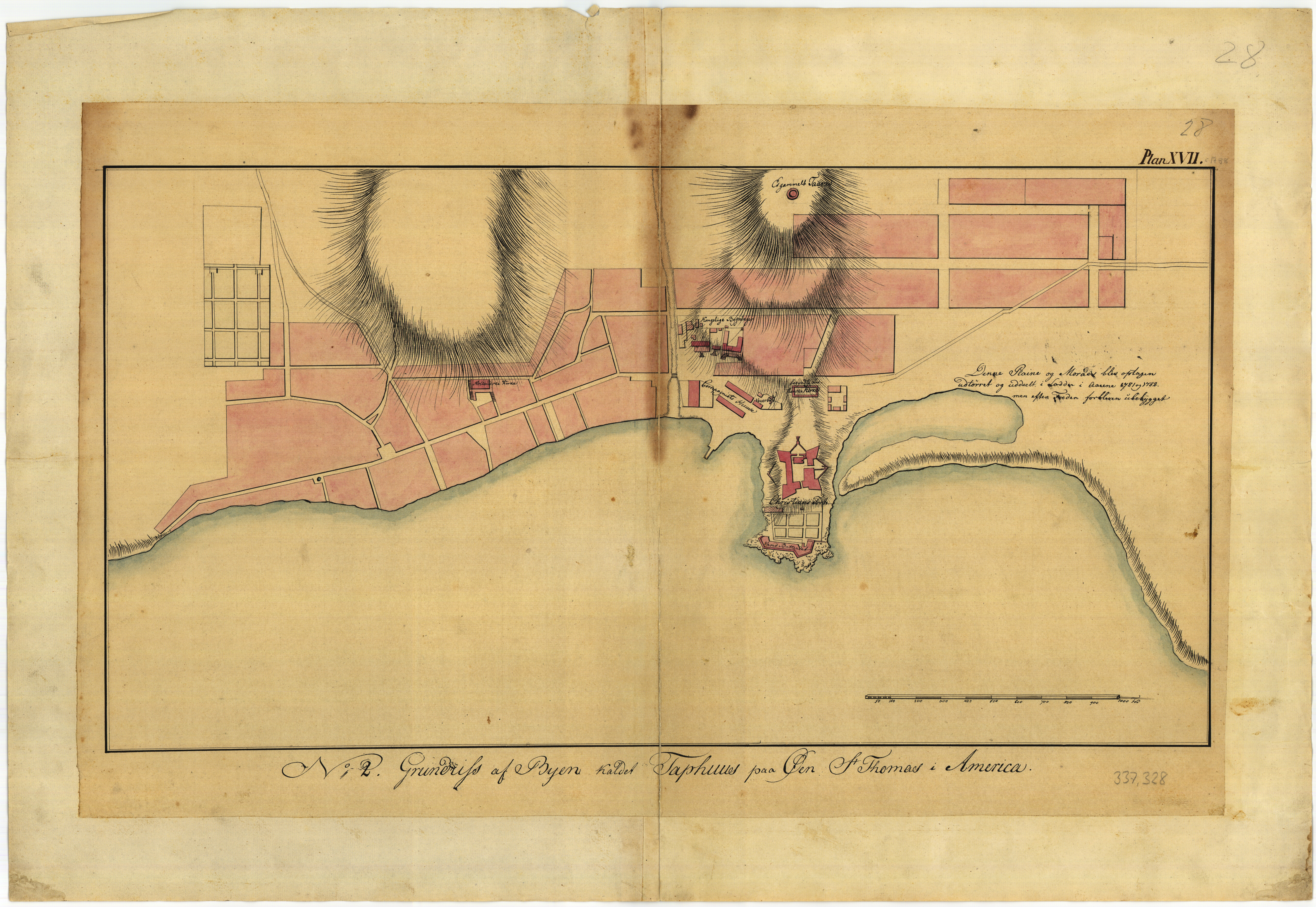
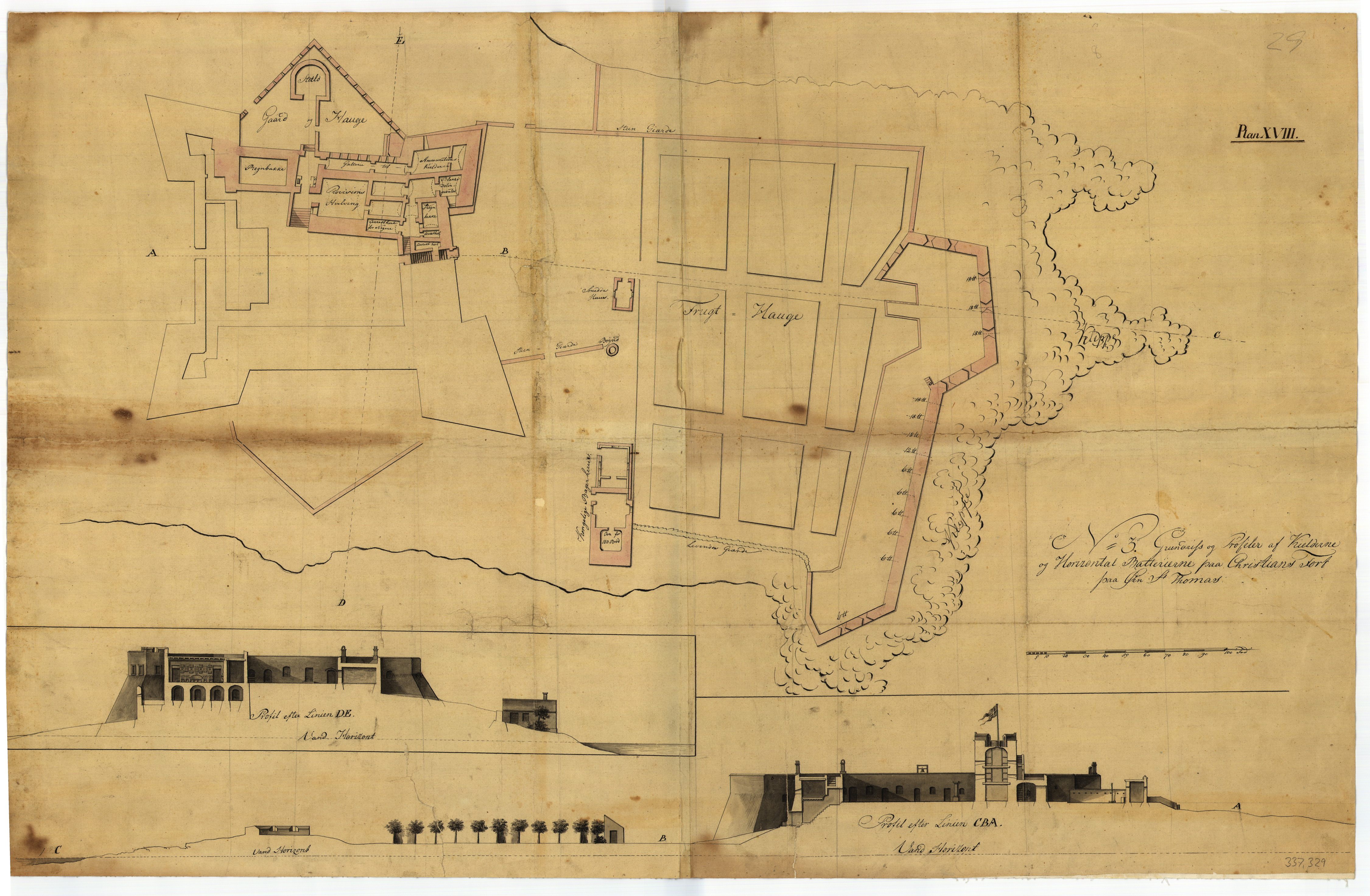
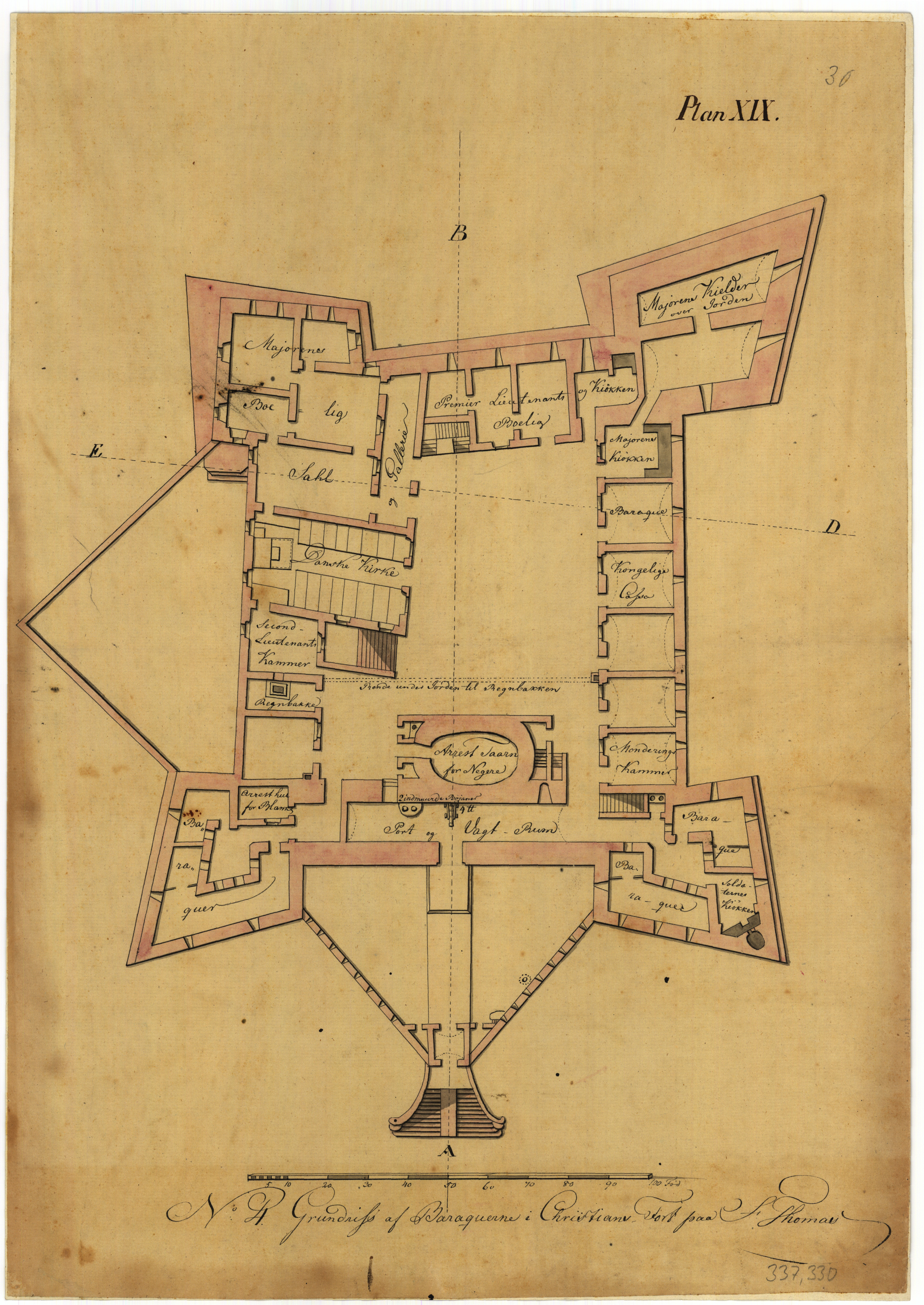
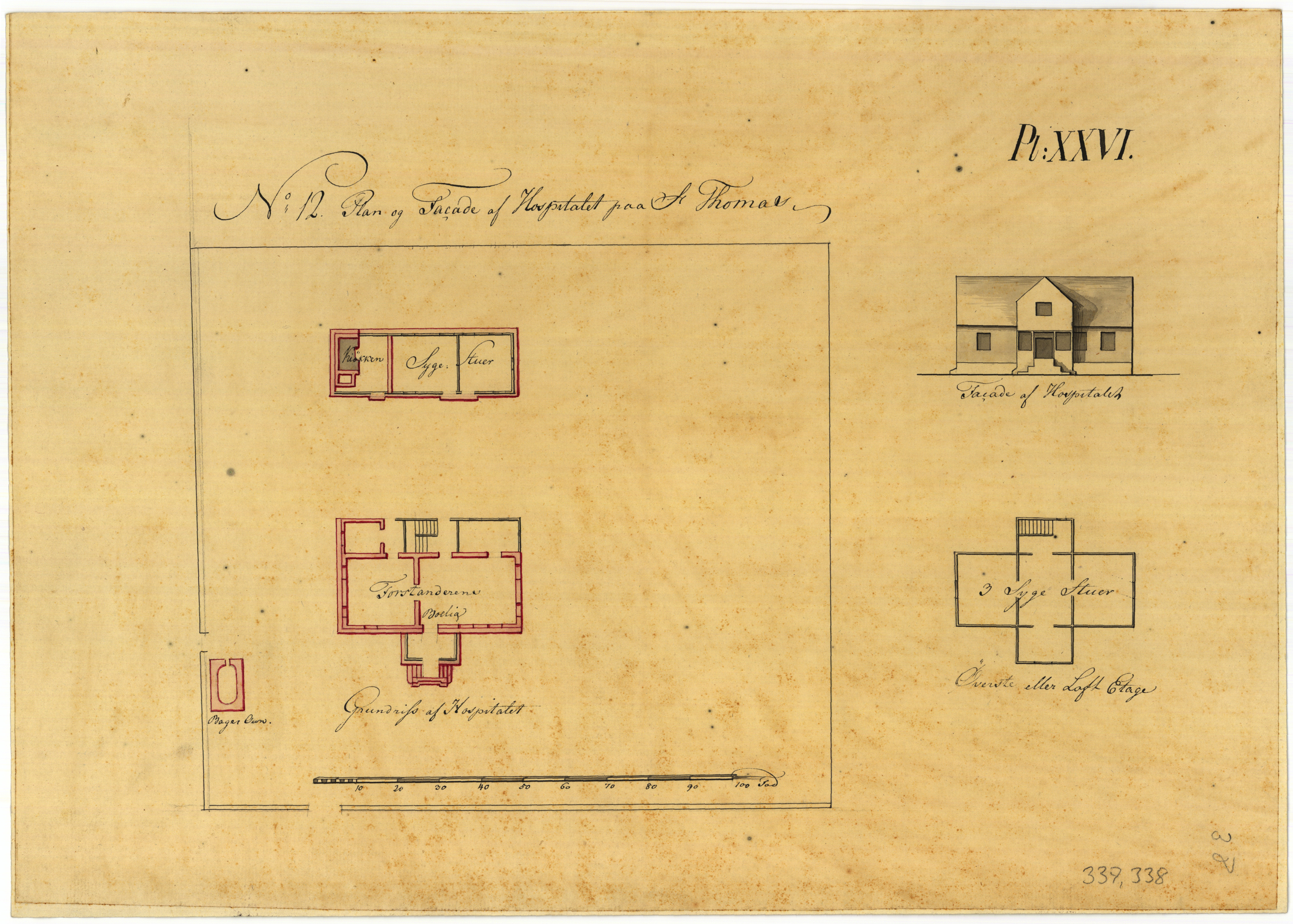
The natural harbor at Charlotte Amalie is one of the absolute best in the West Indies, and it was previously an important regional and international trading center. The entrance is deep, and the bottom is well-suited to holding anchors firmly. The ships cast anchor somewhere in the middle of the harbor, and all transport between ships and land occurred in barges and boats. At the bottom of the bay is the town of Charlotte Amalie with Fort Christian (C) on a small point. The important harbor could be protected by the battery (H) on the west side of the entrance and by the fort’s cannons. In our time the peninsula with this battery has been cut off (at M), and thus the island Hassel Island has been created. The bay Gregoriet (L) was – and is still – used as a harbor. (Danish National Archives, Rentekammersamlingen, no. 337.327)The town on St. Thomas was initially called Taphus and still long into the 1700s, but eventually this name was displaced by Charlotte Amalie. On Oxholm’s map it is clearly evident that it was in part an older district with an irregular street network that had grown organically, in part a new district that had been planned by an engineering officer with an entirely straight sequence of streets. Christiansfort was on a small point in the innermost part of the harbor, and the other royal buildings – commandant’s quarters, bookkeeping and secretariat, warehouses and mast house – were all in the vicinity of the fort. The same applied to the West Indian Trading Company’s buildings. Religious services were still held in a small chapel inside the fort itself, but on Nørregade (Norre Gade) lay the ruins of an uncompleted Danish church. Immediately east of the fort was a stinking lagoon which was a nuisance and a health threat for the entire town. (Danish National Archives, Rentekammersamlingen, no. 337.328).At the bottom of the drawing are two intersecting cross-sections through Christiansfort with a cannon battery turned toward the harbor. The site plan at top shows the coastal battery, which was equipped with powerful cannons and separated from the fort by an orchard. There was also a bakery here with ovens for 120 loaves and a smithy, which both required an open flame. As regards the fort itself, the drawing shows the room division in the cellars. There were jail cells here and storerooms for provisions and powder, along with large cisterns for storing collected rainwater. (Danish National Archives, Rentekammersamlingen, no. 337.329)The drawing shows the layout of the ground floor in Christiansfort. Most of the rooms were used for quarters for officers and non-commissioned officers, but they also provided housing for enlisted soldiers (barracks). In the fort, which was built of stone, it was risked having several kitchens, and some rooms were used for offices. In addition, there was the Danish church, which was arranged in a large hall with entry from the fort yard. Until the end of the 1800s, there was a tower in the yard, the lowest floor of which is here called “arresttårn for negre” (“jail tower for Negroes”). Note that in the guardroom just before the main entrance, there was a small cannon that pointed threateningly toward anyone entering the fort. (Danish National Archives, Rentekammersamlingen, no. 337.330).The drawing shows the uppermost batteries at Christiansfort itself. Here a great deal of rainwater was collected and piped down for storage in the cisterns in the cellar. At the farthest end of the bastions was a sentry box, where the sentries could seek protection against the burning sun or heavy tropical rain. Soldiers lived in the upper floors of the tower. The batteries were equipped with relatively light cannons, intended for close defense. The coastal battery would take care of attacks from the sea side, and two large cannon towers had been built on the high hills behind the fort for defense of the fort’s land side. (Danish National Archives, Rentekammersamlingen, no. 337.331).The cannon battery on the west side of the narrowest place on the entrance was newly constructed in Oxholm’s time. A small guardhouse and an outbuilding with kitchen and privies had been laboriously constructed on the steep cliff. The battery was equipped with six cannons that could easily prevent an enemy’s ships from forcing their way into the harbor, as they were required to sail closely under the cannons in the narrow inlet. (Danish National Archives, Rentekammersamlingen, no. 337.332).Just as there was a battery on the west side, Oxholm thought there should also be a cannon battery on the east side of the entrance at the narrowest place. The new battery would be heavily equipped with cannons and mortars, and it would be protected by a dry moat planted with the worst prickly cacti available and with a drawbridge above. Inside the battery Oxholm envisioned a guardhouse, a powder room, armory, non-commissioned officers’ room and quarters for the soldiers. The required crew was one corporal and nine men, but in special cases twenty men could be lodged in bunks. (Danish National Archives, Rentekammersamlingen, no. 337.333)The royal warehouse and customs and weighing house were located in the harbor square near Christiansfort. The warehouse was divided into a storehouse for provisions, the king’s warehouse and the supplies for the customs house. But the bulk of the ground floor and the loft were filled with the West Indian Trading Company’s inventories of coffee and other dry goods. Therefore, the king’s own goods had to lie in the street in the baking sun or tropical rain. The warehouse was in poor condition and needed thorough repairs. On the other hand, the smaller customs and weighing house was in excellent condition. It housed offices and a central room with columns where the heavy weights were located. (Danish National Archives, Rentekammersamlingen, no. 337.335)The royal mast house in Charlotte Amalie was reconditioned immediately before Oxholm’s arrival. The large building was exclusively used by the West Indian Trading Company. The ground floor functioned as a warehouse for provisions, sugar and rum in large heavy barrels. In the lowest of the lofts was a bookkeeper’s office with official residence along with inventories of dry goods, such as coffee and cotton. Tobacco was stored in the uppermost loft. (Danish National Archives, Rentekammersamlingen, no. 337.336)Three royal buildings were located close together in Charlotte Amalie: the commandant’s quarters, where Thomas Malleville reigned; the bookkeeper’s building, where bookkeeper Graae worked; and the secretariat, where head cashier Gartner and treasurer Graae were housed with their personnel. The first two buildings mentioned had both been constructed in one floor of wood, with a covered veranda in front, while the third was brick and had two floors. At the extreme right of the drawing, the upper floor of the secretariat building is shown, where the head cashier and the secretary had their residences. The buildings no longer exist. (Danish National Archives, Rentekammersamlingen, no. 337.337).For health reasons the military hospital was located slightly outside the town of Charlotte Amalie itself on a large uncultivated lot. It accepted only military personnel as patients. The modest two-story building was only fourteen meters long. The hospital superintendent had his residence on the ground floor, and on the second floor were three sickrooms. In addition to this, there were two sickrooms and a kitchen in a small separate building. (Danish National Archives, Rentekammersamlingen, no. 337.338).